AEC Technology Updates Straight to Your Inbox
Thank you! Your submission has been received!
Oops! Something went wrong while submitting the form.
By subscribing, you agree to our Privacy Policy and consent to receive updates from our company.


.webp)
.svg)


January 8, 2026

12:59 pm

Digital technology has changed how we measure, document, and understand physical spaces. One method gaining attention across engineering, construction, and planning is 3D scanning. Many people ask What is 3D scanning, especially as it becomes more visible in modern projects. At its core, it is a way to capture the shape and details of real-world objects or environments and turn them into accurate digital models.
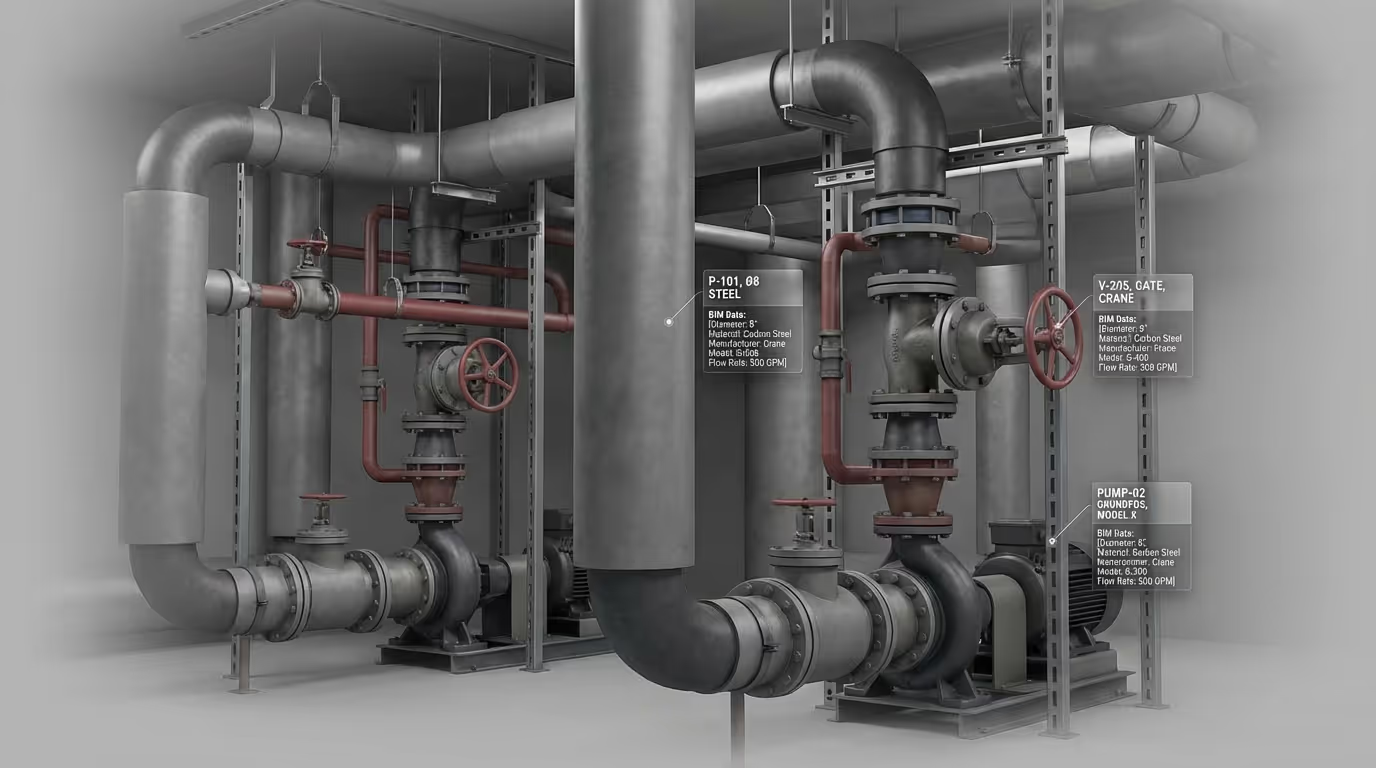
In simple terms, 3D scanning collects millions of data points from surfaces to create a detailed digital representation. These scans help professionals visualize spaces, take precise measurements, and reduce uncertainty before making decisions. Techniques such as 3d laser scanning allow data to be captured quickly without physical contact, which is especially useful for complex or large-scale sites.
Plansrow works with these technologies to support planning, mapping, and spatial understanding across different industries.
3D scanning may sound technical, but the idea is simple. A scanner sends out signals such as laser beams or light patterns that bounce off surfaces. The scanner then measures how long it takes for the signal to return. This information is used to calculate distance and shape.
When repeated millions of times, these measurements form a digital model that closely matches the real object or environment. The result is often called a point cloud, which is a dense collection of points representing surfaces in three-dimensional space. This model can be viewed, measured, and analyzed using specialized software.
Unlike manual measuring tools, 3D scanning captures entire surfaces rather than individual points. This means professionals do not have to decide in advance what needs to be measured. Everything within the scanned area is recorded and can be reviewed later if new questions arise.
Traditional methods often require multiple site visits and repeated measurements. With 3D scanning, one well-planned scan session can provide enough information for ongoing analysis. This difference makes the technology especially useful when working with complex structures, large spaces, or environments that are difficult to access.
Traditional measurement methods rely heavily on manual tools, which can be time-consuming and prone to error. 3D scanning improves accuracy and efficiency by capturing complete environments in a short amount of time. It also reduces the need for repeated site visits, which helps save resources and minimize disruption.
As projects become more complex, having reliable digital data early in the process helps teams identify potential issues before they turn into costly problems. This is one reason 3D scanning is increasingly used alongside modern design and planning workflows.
To understand how this technology fits into real projects, it helps to look at the 3D scanning process in simple stages. First, the scanner is positioned at strategic locations around the object or site. Each scan captures a portion of the environment from that viewpoint.
Next, multiple scans are combined into a single dataset. This step aligns the scans so they form a complete and accurate representation. The combined data is then cleaned to remove unnecessary points and refined for clarity.
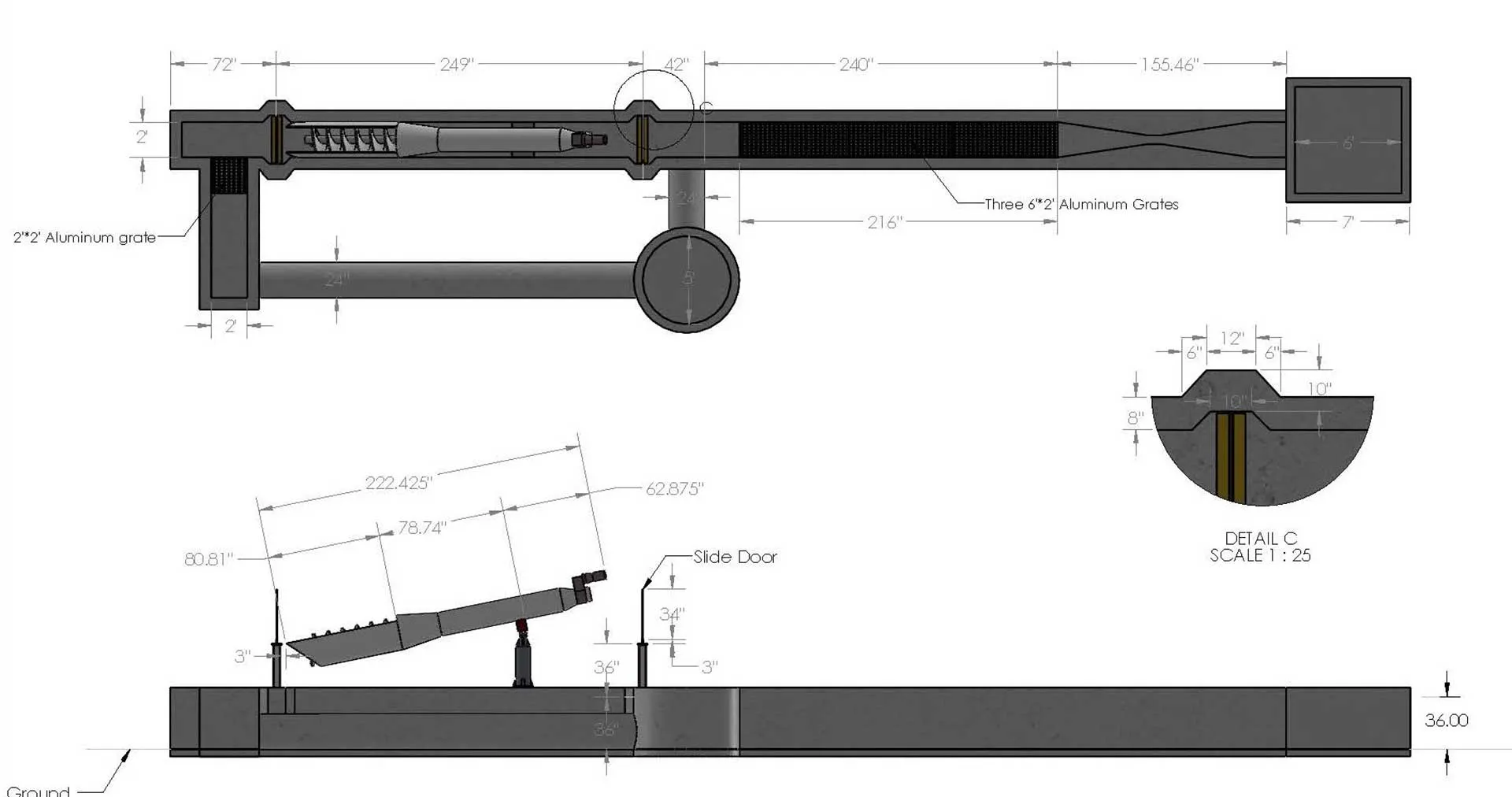
Once processed, the scan can be converted into usable formats such as 3D models, floor plans, or measurement-ready datasets. It allows professionals to work with the data in ways that support planning, design, and analysis.
There are several types of 3D scanning, each suited to different needs. Laser scanning is commonly used for buildings, infrastructure, and large outdoor areas. Structured light scanning is often applied to smaller objects that require great detail.
Photogrammetry is another method that uses overlapping photographs to build 3D models. While it relies more on images than lasers, it still follows similar principles of capturing and reconstructing surfaces digitally.
Choosing the right method depends on factors such as scale, accuracy requirements, and environmental conditions.
Today, 3D scanning applications extend across many industries. In construction, scans help document existing conditions before renovations begin. In urban planning, they support accurate mapping of land and infrastructure. Surveyors use scans to collect terrain data efficiently, while engineers rely on them to assess structures safely.
The technology is also used in heritage preservation, helping document historical sites without physical contact. Across these fields, the value lies in having reliable digital information that supports informed decision-making.
One of the key advantages of 3D scanning is its ability to improve communication. Visual models make it easier for teams to understand complex spaces and share insights with stakeholders who may not have technical backgrounds.
Scanned data also creates a long-term record of conditions at a specific point in time. This can be useful for tracking changes, managing assets, and supporting future projects without starting from scratch.
While 3D scanning is highly accurate, results still depend on proper setup, calibration, and data handling. Environmental factors such as lighting, surface reflectivity, and movement can affect scan quality.
This is why experience and planning are important. Careful scanning practices ensure the data reflects real-world conditions as closely as possible, reducing the need for corrections later in the workflow.
For those new to the topic, the Steps in 3D scanning can be summarized as preparation, data capture, processing, and analysis. Each step builds on the previous one, making consistency and attention to detail important throughout the workflow.
By following these steps, professionals can move from raw measurements to digital outputs that support practical use cases.
3D scanning continues to shape how physical environments are documented and understood. It provides a reliable bridge between the digital analysis, helping reduce uncertainty and improve planning outcomes. Rather than replacing traditional knowledge, it enhances it with detailed, measurable insight.
Plansrow operates within this evolving landscape, applying 3D scanning technologies to support accurate spatial understanding and data-driven planning. For anyone interested in how digital tools improve real-world decision-making, learning the basics of 3D scanning is a valuable starting point.
1. Is 3D scanning only used for large construction projects?
No, it is used for both large and small projects, including buildings, objects, and outdoor environments.
2. How accurate is 3D scanning data?
Accuracy can be very high, often within millimeters, when equipment is properly used and data is processed correctly.
3. Does 3D scanning replace traditional surveying?
It does not replace it entirely, but often complements traditional methods by adding speed and detail.
4. How long does a typical scan take?
Scan time varies based on size and complexity, but many scans are completed within minutes per setup.
5. Can scanned data be reused later?
Yes, stored scan data can be revisited for future measurements, analysis, or planning needs
By subscribing, you agree to our Privacy Policy and consent to receive updates from our company.