


As-Built Drawings
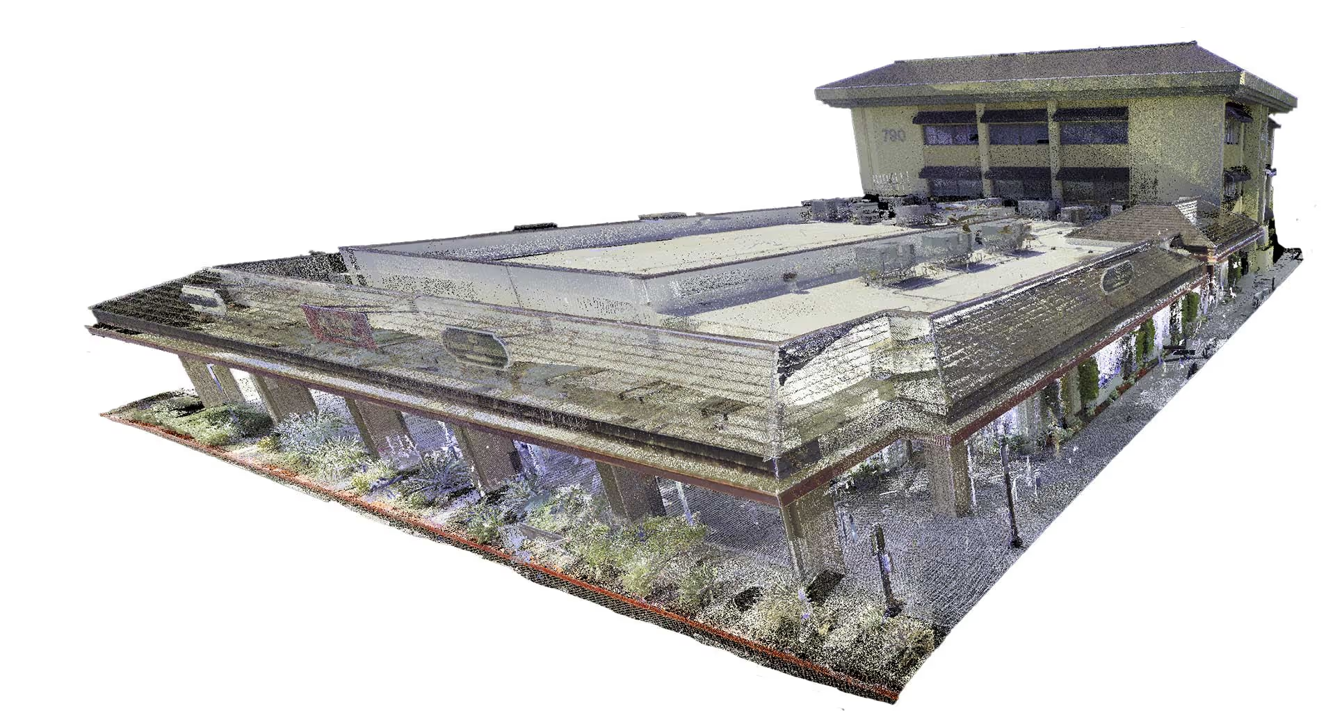
Plansrow provides precise 2D as-built drawings to support architecture, engineering, and construction workflows. Using advanced 3D laser scanning, we capture structural, architectural, and MEP system dimensions with accuracy typically ranging from 2–4 mm, ensuring highly reliable field documentation.
Our Mapping and Modeling team converts point cloud data into clean, organized 2D CAD drawings and, when needed, can also produce detailed 3D BIM models for coordination, planning, and virtual design environments. With accurate measurements, clear drawing standards, and dependable model geometry, you gain confidence in decision-making while reducing costly rework and uncertainty.
Plansrow’s as-built drawings help you:
- Clearly understand building layouts, materials, and existing conditions
- Work from accurate floor plans, sections, elevations, and reflected ceiling plans
- Communicate design intent and project requirements effectively
- Verify compliance with codes, zoning rules, and safety standards
- Coordinate with consultants and trades to reduce clashes and change orders
- Support future renovations, upgrades, and facility lifecycle planning

.svg)
Our As-Built Process (Fast and Simple)
Get StartedStep 1
Site Review and Scan Setup
We walk the site, confirm access, and plan the scan path to ensure full coverage. This prevents blind spots and guarantees accurate existing conditions from the start.
High-Resolution Data Capture
High-Resolution Data Capture
Using survey-grade 3D laser scanners, we capture millions of precise measurements from every angle. Each scan location is carefully placed to document all rooms, corridors, structures, and hard to reach areas.

Step 3
Data Registration and Processing
All scan data is aligned, cleaned, and registered into a single unified point cloud. From this, our modeling team builds accurate CAD drawings or BIM models depending on your project needs. data mapping
Model & Deliverable Handoff
You receive DWG, PDF, and Revit (if needed) ready for design, permitting, and construction.

Access accurate building documentation for renovation and maintenance planning.
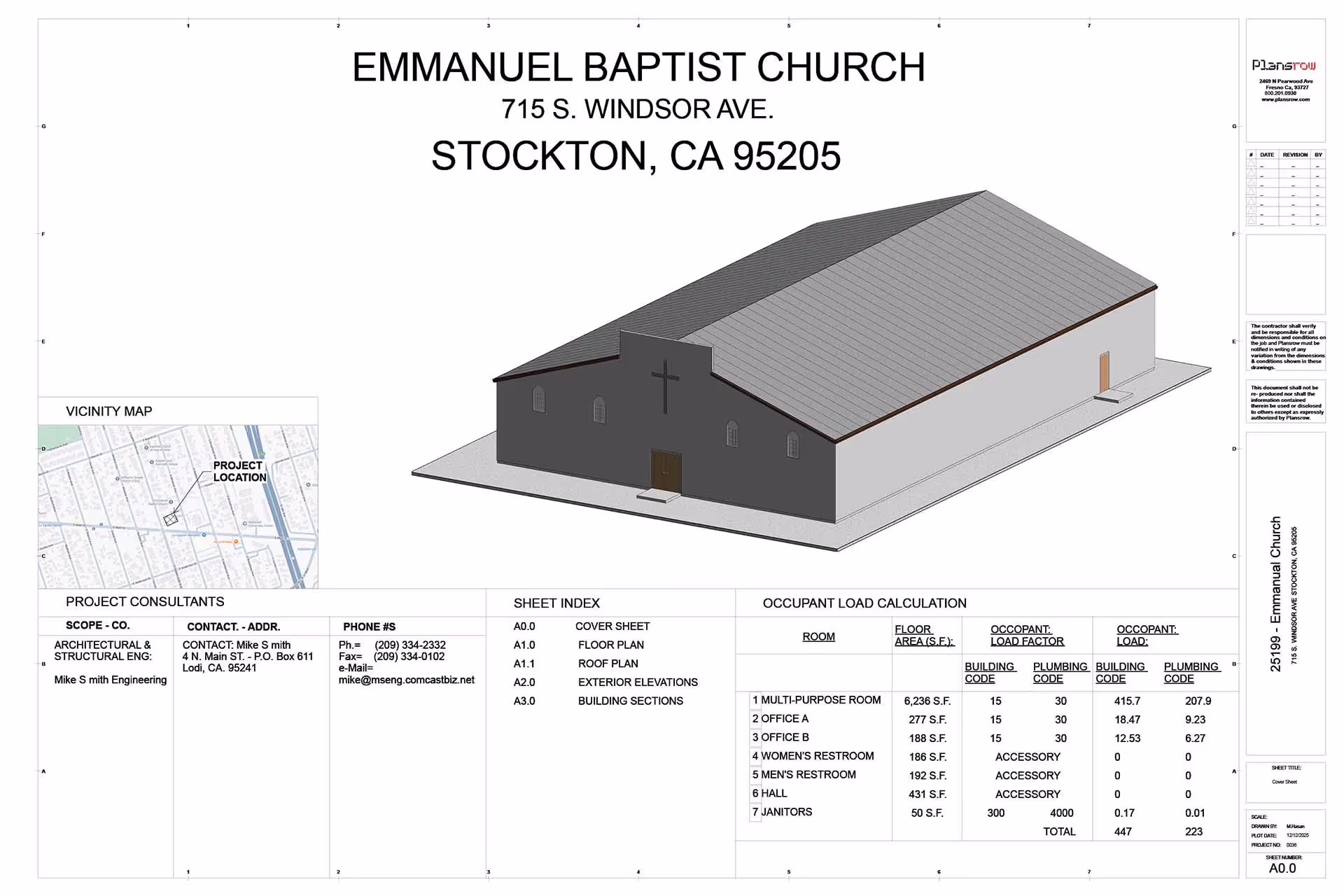
2D drawings provide an accurate visual representation of a building or project layout, including measurements, geometry, and technical details. They serve as a foundational communication tool between design, engineering, and construction teams throughout the project lifecycle.
With a reliable base drawing, clients can layer in updates such as revised layouts, design changes, structural adjustments, or mechanical system components. Additional details like dimensions, text notes, callouts, leaders, and tables can be added to clearly communicate intent or highlight areas requiring coordination.
These engineering-grade drawings also establish tolerances for key dimensions, ensuring alignment with project specifications, regulatory requirements, and industry standards. As a result, 2D drawings remain essential for decision-making, coordination, and accurate execution in the field.
See Our Work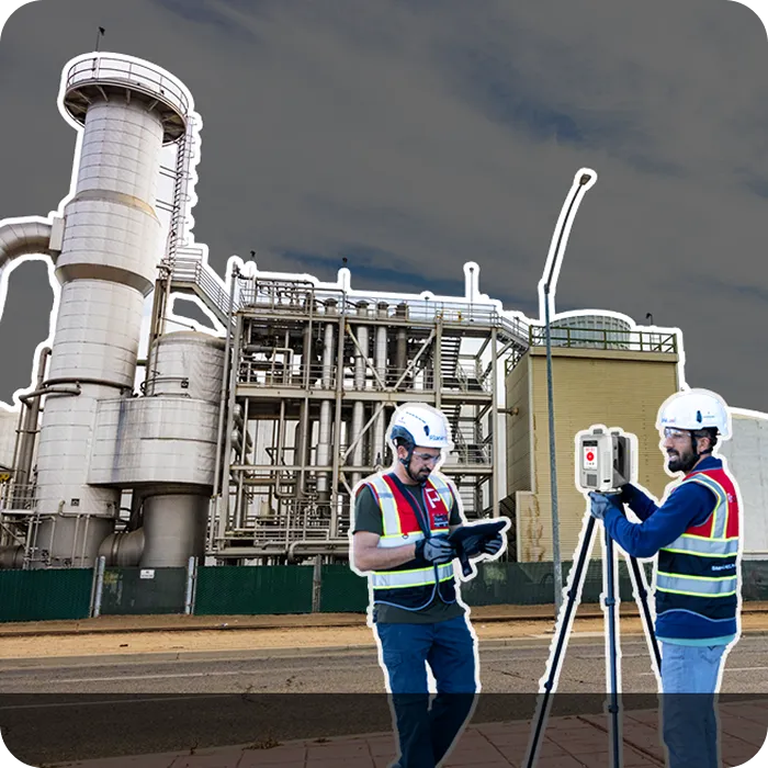
Ready to elevate your building measurements?
Partner with our expert team using advanced 3D laser scanning technology for project success.
What Types of 2D CAD Drawings Does Plansrow Provide?
Partner with our expert team using advanced 3D laser scanning technology for project success.
Site Plans
A site plan (also known as a plot plan) is a graphic representation of existing site conditions. It includes the full layout of the property showing buildings, paving, utilities, landscape features, access points, and terrain captured in one clear and accurate depiction.
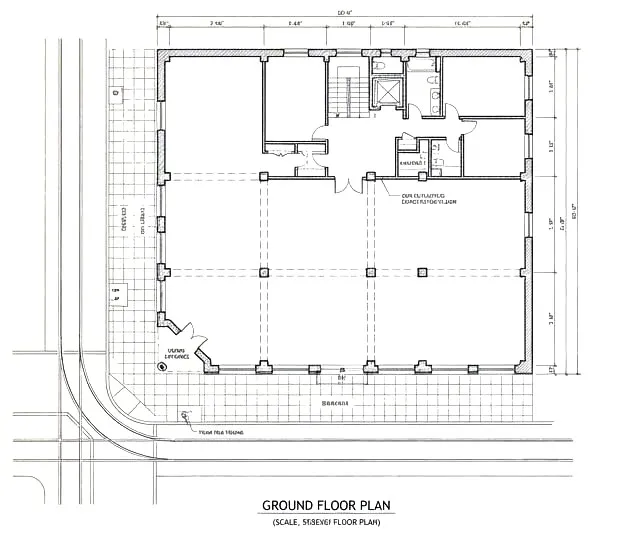
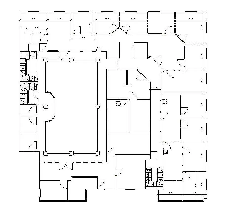
Floor Plans
Floor plans illustrate the spatial layout of rooms, circulation paths, walls, doors, windows, and fixed elements. These drawings are commonly used during design review, retrofit planning, and construction coordination.
Interior Elevations
Interior elevation drawings display interior wall surfaces from a straight-on viewpoint. They show the placement and dimensions of finishes, doors, windows, millwork, fixtures, and other key interior elements.
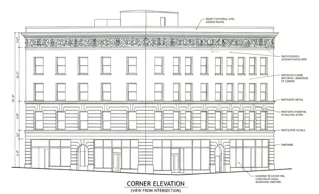
Exterior Elevations
Exterior elevation drawings document a building’s façade and exterior conditions. They clearly show the outline, massing, and placement of exterior features such as doors, windows, floor levels, and architectural elements helping design teams understand alignment and relationships between building components.
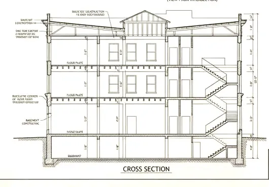
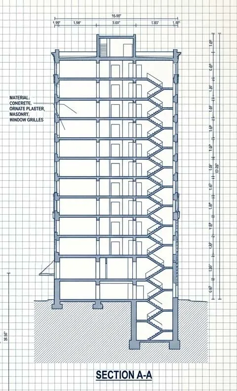
Sections / Cross Sections
Sections provide a cut-through viewpoint of the building to reveal structural and interior relationships that are not visible in plans or elevations. These drawings help teams understand vertical connections, material layering, and spatial organization.
Details
Detail drawings zoom in on specific elements such as assemblies, connections, or specialty components to provide greater clarity on dimensioning, materials, and construction requirements.
Isometric Drawings
Isometric drawings present a 3D object in a 2D format by representing each axis at a consistent angle, typically 30 degrees. This creates the illusion of depth, helping teams visualize complex spaces, assemblies, or components more intuitively.
Mechanical & Electrical Drawings
These drawings capture building systems including mechanical, electrical, plumbing, and HVAC layouts. They are essential for coordination, renovation planning, and system verification.
Reflected Ceiling Plans (RCPs)
RCPs show ceiling features such as height variations, lighting layouts, ventilation grilles, sprinkler heads, and other overhead components mirrored as if viewed in a reflective surface.
Why Do Accurate, Up-to-Date As-Built Drawings Matter?
With precise as-built drawings generated from our laser scan data, your team can plan renovations and construction with confidence, minimizing change orders, delays, and unnecessary costs.
See Our WorkVerified Building Record
Gain a reliable snapshot of your building’s actual conditions, including changes made over time. This ensures your team always works from an accurate, trusted source of truth.
Exact Measurements and True Layouts
Our high-accuracy scans capture real-world dimensions and layouts with precision. Your design and construction teams can make confident decisions without relying on outdated or assumed information.
Better Planning for Renovation and Maintenance
Up-to-date documentation helps you anticipate issues, plan upgrades, and schedule work more efficiently. Clear information reduces uncertainty and supports smoother renovation and maintenance workflows.
Minimize Costly Revisions
Starting with precise as-built data significantly reduces design errors and field conflicts. Fewer surprises in the field means fewer change orders and less rework.
Stronger Team Coordination
When every stakeholder works from the same accurate information, collaboration improves naturally. This helps speed up decisions and keeps the entire project moving in sync.
Clear Documentation for Final Closeout
Provide owners and facility teams with accurate, dependable records for handover and compliance. Updated as-builts help meet regulatory requirements and support long-term facility management.
What You Get with Our As-Built Drawing Service
We tailor deliverables to your project type, software, and level of detail.
Standard As-Built Packages
.svg)
Reflected Ceiling Plans (RCP) – ceiling heights, soffits, lighting, diffusers
Building Sections & Profiles – vertical relationships, roof structure, floor elevations
Roof Plans – slopes, drains, mechanical equipment
Site Plans – landscape, curbs, utilities, sidewalks (if requested)
Exterior Elevations – materials, openings, heights, architectural elements
Floor Plans – walls, doors, windows, partitions, structural elements
Advanced As-Built Packages
.svg)
MEP/VAV/Fan Coil layouts
Fire Protection as-builts
Structural framing plans
Equipment locations & verification
Finish schedules and room data
Scan to BIM (Revit/Archicad models)
Why Plansrow As-Builts Are Better
We tailor deliverables to your project type, software, and level of detail.

Contractors
Get a digital record for future renovations, tenant improvements, or expansions.
.webp)
Architects and Engineers
Clean linework optimized for architects and engineers
.webp)
Fast Turnaround
Fast turnaround (you already have a reputation for fast delivery)
.webp)
Complete 3D scans
Single vendor for 3D scanning + as-builts + BIM.


Our Services
At Plansrow, we transform the built environment into precise, actionable data. Using advanced 3D laser scanning, we capture every detail of your site with exceptional accuracy, giving you the clarity needed to make confident decisions at every stage of a project. Our deliverables include clean point clouds, dependable CAD documentation, and BIM models built in Revit or Archicad, all designed to eliminate guesswork and support renovation, design, and long-term facility management with total confidence.

3D Laser Scanning
Capture exact architectural, structural, and MEP dimensions and layouts of existing buildings, facilities, and sites in a point cloud.

As-Built Drawings
Receive up-to-date floor plans, elevations, sections, details, isometric drawings, reflected ceiling plans, and more.
.svg)
BIM Modeling
A digital twin of buildings and infrastructure advances collaboration on design, construction, and operations.

Design Builds & Remodels

Education

Retail & Restaurant Construction

Water & Sewer

Engineering & Surveying

Civil, Road & Bridge

Power Transmission & Distribution

Telecom

Oil & Gas

Power Generation

Facilities

Electric Vehicle Charging

One Call

Environmental
Frequently Asked Questions
Find answers to commonly asked questions about our 3D laser scanning services.
How accurate are your as-built drawings
They are derived from point cloud data with millimeter-grade accuracy. Far more reliable than conventional measurement workflows.
How fast can you deliver drawings
Most commercial projects are completed within days, not weeks depending on building size and model detail.
Can you also create a BIM model from the scans
Yes. We offer full Scan-To-BIM services at any LOD (200–400).
Do you work across California
Yes. We service all California cities Fresno, Clovis, Bay Area, Los Angeles, Sacramento, and more.
Do you work outside of California?
Yes. We work on projects across multiple states. Plansrow has operational hubs in multiple regions, allowing our team to mobilize quickly. If your project is awarded to us, we can be set up and fully deployed on-site within two business days, anywhere in the U.S.
From Our community
Here's what other subscribers had to say about us online.


Jose Lemus
Principal | LandDesign

Nathan Jefferson
Director of Sales | 4-Creeks
AEC Technology Updates Straight to Your Inbox
Thank you! Your submission has been received!
Oops! Something went wrong while submitting the form.
By subscribing, you agree to our Privacy Policy and consent to receive updates from our company.


.webp)
.svg)